That's it, This week is over. It's back to my cabin tomorrow, for another five days of solitude.


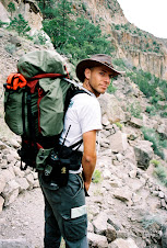
On Friday I went on one of the most beautiful hikes you could take- in my opinion. Brian drove me outside of the park to Vales Caldera natural preserve. The border between the park and the Caldera is a ridge of peaks called Rabbit Ridge. Both the Caldera and the park have trails that climb that ridge, and there are two very impressive peaks that these trails climb to- Rabbit ridge peak, and Scooter peak. Brian dropped me off at Coyote Call- a trail head on the caldera side, and I hiked up that trail to the top of Rabbit ridge. From there, off trail, just along the saddle between the two peaks, I hiked to scooter peak and from there I dropped into the park. It was a clear chili morning when I started up the old logging trail that climbs from Coyote Call. The road is well preserved so you have a very wide trail that climbs at a steep but constant grade almost all the way to the top. I was wearing a short T-shirt and was playing the fine line between sunny-warm and shady-chili as the sun rose through the trees. The last half mile of the climb breaks off from the logging road, so you're winding between trees and boulders. At the top the view opens up towards the caldera, when you reach a boulder filed- the remnant of an old avalanche. I got to see some more elk up there, but they were quick to get away from me.
From there, my hike across the saddle to Scooter peak was off trail and along the boundary between the park and the caldera, so I was just walking in the woods. It's a pretty steep drop and climb, but it was a nice morning and I took my time. Had an early lunch at the top of Scooter- two of my (now famous) home made granola bars.
I dropped down the slope of Scooter into the park. The forest on that side of the mountain was a lot more dense, with fallen trees and bushes all over the place. But making my way through it was really beautiful, plus here and there I picked up stretches of an old forgotten logging trail that helped me get down. When I got down to the bottom I radioed in for a pick up and ended up waiting for almost an hour. By the time Virginia from fee-collection showed up (Law Enforcement folks were all busy- that's why it took so long), I was taking a nap in the sun at Graduation Flats, right next to a pile of Bud light cans left over by the great white hunters.
On Saturday and Sunday Shanon, Bree, Gumaz, Caroline and I drove down to Tesuque (a pueblo about 40 minutes away from the park, on the way to Santa Fe) for the Wilderness First Aid class. It was being given in the Santa Fe Mountain Center.
http://www.sf-mc.com/index.html

On Sunday night, Gumaz had a gathering at his house. We all made something and came over. I got to meet a whole bunch of people from the fire crews for the first time. They've all been "Working the fires" in Montana for the past couple of months, and only came back this past week. Maybe now I'll start seeing some people in my little neighborhood down in the canyon. Well, that is, on my days off.
My last hike for the week was on Monday. There is a piece of the park that is detached from the main park. It's a small area called Tsankawi- about 20 minutes drive from the entrance to the park, on the other side of White Rock. It is a mesa with more ruins on it. There is an automated payment station at the entrance, and a ranger opens it up every morning. The plan was not for me to hike the trail, but to go around along the boundary fence. It was a pretty cloudy morning when I headed out to find me a ride. I knew that they were doing some thinning work around Tsankawi and I walked into John Mac's office (Head of the resource division) to see if anyone was headed out there. "Why don't you just grab a car from the car pool?" he asked me. "Because I didn't know I could..." was my hesitant answer. With a swift "Come with me!" John took away any doubt about that matter, and led me to where all the keys were hanging. "Some of these are pretty old vehicles, and people don't like using them, but if you don't mind driving stick-shift, and just need to get to Tsankawi and back, you would be doing me a great favor if you took one of them, since we really ought to get them started and running every once in a while". And that's how I found myself driving a yellow 1985 Suburban, with 5 gears in total- "Reverse", "Low" and 1-3. Not a bad ride at all.
Once I got there I saw that the automatic payment station wasn't opened yet, so I radioed Wendy and asked if she wanted me to do it. She was glad to take me up on that, since it would have saved her the trip, but failed to mention that there was an alarm system. She ended up having to drop whatever it was she was doing and drive down to Tsankawi- to turn off the alarm I triggered. so much for saving her the trip.
My hike went pretty well. For the first two thirds of the way I followed a couple of narrow Mesas and then turned east and crossed a small valley. Then I climbed the ridge on the other side, and just as I was about to drop down towards the road on the eastern boundary and follow it north- for the last third of the way, the clouds got cloudier and it started raining. Then it started raining harder,
There is a large archaeological site that's out there, off trail and off the maps, that I've been told about and I really want to visit it. It's called San Miguel ruin and I will be taking pictures, if I can find it.
This past week was a very slow and calm week. I came back from the backcountry on Monday, had a couple of days off on Tuesday and Wednesday, and even had the opportunity to call the family on the holiday. Then I had Thursday and Friday for day hikes and went to a very well-done wilderness first aid class on Saturday and Sunday. Went on a day hike again on Monday, and a couple more days off which end today. I was also able to squish in some studying- So I might learn some Micro economics after all.
That was the quick sum of things.
Thursday started with Dale and I going on hunting patrol in the morning. It's still bow season out here, and you have to make sure that the hunting is just going on in the forest, and that no one is doing any hunting in the park. Got to tell you- Some of the characters that partake in the sport of Bow hunting are... interesting. And some of them hunt bear too (we are only in Elk and Deer season right now). I mean, you need to be pretty ballsy to hit a bear with an arrow- if you miss the heart and the bear survives- that's one very pissed off animal with teeth and claws running at you, and your weapon of choice is not a fast loading weapon- to say the least. Come to think of it- having an injured bull-elk running towards you might not be that much fun either. Nevertheless, graduation flats (the name of the picnic area/camp ground where most of the hunters park their campers) has been filling up every weekend for the past three weeks. I did get to see my first full size elk that day. 

Around 9:00 am, Brian went on shift (We started at 6:00- those hunters get an ungodly early start- I suppose they listened when their mother told them that the early bird catches the worm), and took over, so we went over to HQ and picked up a sign that needed to be mounted at a trail intersection about 16 miles up canyon from the main park area. Apache springs is one of the only trails I have yet to hike and Dale and I took it into the canyon carrying a post-hole digger and sign post with two signs mounted on it- pointing at all four directions. Dale was nice enough to grab the uncomfortable load of the sign. It's about 2.5 miles each way and let me tell you- this is probably one of the worst designed trails in the park- steep descent with not enough switchbacks. However, since the trail gets very little use- there is little motivation to get a trail crew in to fix it up. Upper Frijoles canyon, I have to tell you, is quite breath taking.
After we got done we headed back to HQ. Dale, and the rest of the law enforcement division had a very long meeting to attend, and I decided to finish the day with a short hike down canyon, on the falls trail, which is probably the most used trail in the park (not counting the paved loop that goes through the main ruin area). This trail got seriously damaged during the flood we had three weeks ago. Bridges were washed away and the creek split and washed over the trail in a few places so the lower you drop as you go- the closer you get to where Frijoles creek runs into the Rio Grande, the harder it is to follow the trail. You can't really get lost- you are hiking up and down a pretty narrow canyon. When I got to the bottom I saw a small white balloon in the sky hovering over what seemed to me like the southern boundary of the park. I radioed it in and finished my hike.
After we got done we headed back to HQ. Dale, and the rest of the law enforcement division had a very long meeting to attend, and I decided to finish the day with a short hike down canyon, on the falls trail, which is probably the most used trail in the park (not counting the paved loop that goes through the main ruin area). This trail got seriously damaged during the flood we had three weeks ago. Bridges were washed away and the creek split and washed over the trail in a few places so the lower you drop as you go- the closer you get to where Frijoles creek runs into the Rio Grande, the harder it is to follow the trail. You can't really get lost- you are hiking up and down a pretty narrow canyon. When I got to the bottom I saw a small white balloon in the sky hovering over what seemed to me like the southern boundary of the park. I radioed it in and finished my hike.
In the evening some of us got together to play Ultimate Frisbee in White Rock, and we could still see the Balloon hover over the park.


The next day I was told by one of the visitor center rangers that at first, when she heard my report over the radio, she thought I was seeing a weather balloon- they sometimes drift over the park, but later that day she was watching the news and they said that the strange balloon was actually a NASA solar balloon 200 feet in diameter, hovering in an altitude of 23 miles. Pretty cool, ha- Not only do I have the instincts of a cat, but also the eyes of a hawk (and a lot of times- the brains of a squirrel, or so I've been told).
On Friday I went on one of the most beautiful hikes you could take- in my opinion. Brian drove me outside of the park to Vales Caldera natural preserve. The border between the park and the Caldera is a ridge of peaks called Rabbit Ridge. Both the Caldera and the park have trails that climb that ridge, and there are two very impressive peaks that these trails climb to- Rabbit ridge peak, and Scooter peak. Brian dropped me off at Coyote Call- a trail head on the caldera side, and I hiked up that trail to the top of Rabbit ridge. From there, off trail, just along the saddle between the two peaks, I hiked to scooter peak and from there I dropped into the park. It was a clear chili morning when I started up the old logging trail that climbs from Coyote Call. The road is well preserved so you have a very wide trail that climbs at a steep but constant grade almost all the way to the top. I was wearing a short T-shirt and was playing the fine line between sunny-warm and shady-chili as the sun rose through the trees. The last half mile of the climb breaks off from the logging road, so you're winding between trees and boulders. At the top the view opens up towards the caldera, when you reach a boulder filed- the remnant of an old avalanche.
I got to see some more elk up there, but they were quick to get away from me.From there, my hike across the saddle to Scooter peak was off trail and along the boundary between the park and the caldera, so I was just walking in the woods. It's a pretty steep drop and climb, but it was a nice morning and I took my time. Had an early lunch at the top of Scooter- two of my (now famous) home made granola bars.

I dropped down the slope of Scooter into the park. The forest on that side of the mountain was a lot more dense, with fallen trees and bushes all over the place. But making my way through it was really beautiful, plus here and there I picked up stretches of an old forgotten logging trail that helped me get down. When I got down to the bottom I radioed in for a pick up and ended up waiting for almost an hour. By the time Virginia from fee-collection showed up (Law Enforcement folks were all busy- that's why it took so long), I was taking a nap in the sun at Graduation Flats, right next to a pile of Bud light cans left over by the great white hunters.
On Saturday and Sunday Shanon, Bree, Gumaz, Caroline and I drove down to Tesuque (a pueblo about 40 minutes away from the park, on the way to Santa Fe) for the Wilderness First Aid class. It was being given in the Santa Fe Mountain Center.
http://www.sf-mc.com/index.html
Their counselors take groups out on trips and they needed the class for them. Since getting two instructors for two days is quite expensive, they invited other agencies around the area to send their people to the class- and that's how 5 people from the park got in on it. There were about 10 folks from the mountain center and we were 32 altogether.
This was probably one of the best first aid classes I've ever taken. They had simulations going all the time- with good case stories for the patients and even make-up and props. Each time, two thirds of the groups coupled up and got take care of seemingly real patients- with aches, pains, complaints and bruises. Very well done. Another good thing about this class was that the way of thinking about the situation was different than what I'm used to. In Israel, in all the first aid classes I've taken up until now, it was always- "patch it up and go". Find what's going to kill your patient now, deal with it to the best of your ability and get him to an ambulance. This works under the logic that you are never more than an hour away from an ambulance (or a helicopter rescue)- true for Israel. In this class, the thought was- what if you are in the back country and it's three days hiking to the nearest road? With no cell phone reception... Imagine you have to spend three days with this person until your other friend, that went to get help, is able to reach someone. How do you keep him warm? How do you prevent his wounds from getting infected? How do you change dressing?
 I learned a lot of clever tips and practiced all kinds of stuff. For a two day course- It was awesome.


On Sunday night, Gumaz had a gathering at his house. We all made something and came over. I got to meet a whole bunch of people from the fire crews for the first time. They've all been "Working the fires" in Montana for the past couple of months, and only came back this past week. Maybe now I'll start seeing some people in my little neighborhood down in the canyon. Well, that is, on my days off.
My last hike for the week was on Monday. There is a piece of the park that is detached from the main park. It's a small area called Tsankawi- about 20 minutes drive from the entrance to the park, on the other side of White Rock. It is a mesa with more ruins on it. There is an automated payment station at the entrance, and a ranger opens it up every morning. The plan was not for me to hike the trail, but to go around along the boundary fence. It was a pretty cloudy morning when I headed out to find me a ride. I knew that they were doing some thinning work around Tsankawi and I walked into John Mac's office (Head of the resource division) to see if anyone was headed out there. "Why don't you just grab a car from the car pool?" he asked me. "Because I didn't know I could..." was my hesitant answer. With a swift "Come with me!" John took away any doubt about that matter, and led me to where all the keys were hanging. "Some of these are pretty old vehicles, and people don't like using them, but if you don't mind driving stick-shift, and just need to get to Tsankawi and back, you would be doing me a great favor if you took one of them, since we really ought to get them started and running every once in a while". And that's how I found myself driving a yellow 1985 Suburban, with 5 gears in total- "Reverse", "Low" and 1-3. Not a bad ride at all.
Once I got there I saw that the automatic payment station wasn't opened yet, so I radioed Wendy and asked if she wanted me to do it. She was glad to take me up on that, since it would have saved her the trip, but failed to mention that there was an alarm system. She ended up having to drop whatever it was she was doing and drive down to Tsankawi- to turn off the alarm I triggered. so much for saving her the trip.
My hike went pretty well. For the first two thirds of the way I followed a couple of narrow Mesas and then turned east and crossed a small valley. Then I climbed the ridge on the other side, and just as I was about to drop down towards the road on the eastern boundary and follow it north- for the last third of the way, the clouds got cloudier and it started raining. Then it started raining harder,
And then it started hailing. I was pretty happy to be off the mesa top, since there was quite a bit of lightning going on. Except for the general discomfort of walking in heavy rain I was doing alright. I had my poncho and was only worried about my camera getting wet.

Towards the end of my hike I got to Dutches castle- and the rain stopped for just enough time for me to take a couple of pictures. The art of native pottery was almost gone by the middle of the early 1900's. Dutch's Castle was built by a woman by the name of Madame Vera von Blumenthal as a school for pottery for the pueblos, the name was given after she was already gone.
 http://www.nps.gov/band/photosmultimedia/tt-vy-stop-9.htm

Unfortunately, that wasn't the end of the storm, and I was singing in the rain for the rest of my hike.

No comments:
Post a Comment